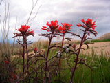
 | An Article from Aaron's Article ArchiveThe Wave - Standstone in Motion Photo: Shinob Kibe PaintbrushIPv4You are not logged in. Click here to log in. |
Use Google to search aarongifford.com:
Here is one of my web log entries, perhaps from my Yakkity Yak page, What's New page, or one of my Astounding Adventures from my Geocaching section: The Wave - Standstone in Motion
Saturday, 01 May 2004 11:58 AM MDT
Astounding Adventures
THIS IS A VERY VERY ROUGH DRAFT, REALLY JUST A COLLECTION OF BRAINSTORMING...
 'The Wave' - Tuesday, 29 October 2002Virtual Cache:The Wave 'The Wave' - Tuesday, 29 October 2002Virtual Cache:The Wave
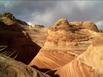
The Wave is a spectacular sandstone formation on the slopes of the Coyote Buttes in the beautiful and rugged Paria Canyon - Vermillion Cliffs Wilderness Area, several miles south of U.S. Highway 89, about half-way between Kanab, Utah and Page, Arizona, located in northern Arizona near the Utah-Arizona border. A Permit is Required The Wave is in a wilderness area -- a permit is absolutely required. You must obey the rules and regulations that apply. The area is regularly and thoroughly partrolled and the rules are strictly enforced. The rules help to preserve and maintain this and other wonderous national geological treasures so that they may be better enjoyed by all of us and by future generations. Permits for hiking to The Wave cost $5.00 (US Dollars) per person. The maximum size of any group is six people. The Wave is located within the North Coyote Butte Wilderness Area, and a maximum of twenty persons in total are allowed into this area per day. Of the twenty daily permits into the north area, only ten of those permits can be obtained well in advance. The remaining ten permits are made available in person at the BLM field office one day in advance. Guided tours and/or commercial groups or organizations must obtain additional permits. Two Ways to Obtain Permits
To obtain a permit, you must provide the following:
$5 per person per day AM MST the Kanab Field Office of the BLM So to be sure you are able to obtain an advance permit, viSeven months before your planned hike, at noon (Arizona time - Mountain Standard Time, which is GMT -0700 hours) Getting to the Trailhead Waypoint: WV01TNOF N. 37� 00.570'
On Highway 89, about half-way between Kanab, Utah and Page, Arizona, turn south on to a dirt road, Rock House Road, and follow it south-by-southwest down Coyote Valley for about 8.3 miles to the Wire Pass Trailhead. A high-clearance two-wheel-drive vehicle should be fine except during rain or inclement weather.
W. 111� 58.608' Leave Highway 89 and turn south on Rock House Road 4800 ft. elevation - Utah Waypoint: WV02TRHD N. 37� 01.146'
Restrooms are available at the trailhead, but there is no water, so bring plenty with you.
W. 112� 01.492' Wire Pass Trailhead (Parking and Restrooms - No Water) 4870 ft. elevation - Utah Parking lot and trailhead at about 4875 ft. elevation, in Utah located of Rock House Road The Hike From the trailhead, the hike is over 2 1/2 miles one-way through the desert. The terrain varies from sandy, to slick-rock sandstone. Most of it is easy to moderate. Be ready to scrabble up a slope as necessary. The elevation difference from the trailhead to The Wave is only about 350 feet, but the trail does quite a bit of up-and-down, so in reality, you probably climb 500-700 feet vertically over the course of the round-trip hike. The biggest climb is the last quarter mile just below The Wave where you ascend about 200 feet. Most of the trail is in Kane County, Utah, but the last third of a mile and The Wave itsself is in Coconino County, Arizona From the Wire Pass Trailhead, follow the trail as it skirts the edge, then soon enters the Coyote Wash and follows the wash bottom as it makes a large horseshoe bend. Waypoint: WV03LWSH N. 37� 01.198'
Once the wash is headed northward again, having curved around the large horseshoe bend, about a half-mile or so from the trailhead, keep your eyes out along the right-hand side of the wash. Look for a sign and/or a trail/path that climbs up the hillside.
W. 112� 01.081' Leave the wash and follow the trail, an old road, up the hillside to the east. 4815 ft. elevation - Utah At this point, you leave the Wire Pass trail which continues along the wash bottom, and follow what was once an old road up the eastern hillside. Continue along the path/road eastward over the hill, then southeastward down into the next valley for a little over a half-mile. As the trail approaches the bottom of the wash in the valley, it may fade. Waypoint: WV04CLMB N. 37� 00.941'
Ahead is a north-south sandstone ridge that you will need to cross. There are two different sandstone saddles that people cross. My group crossed the northernmost saddle on our way out, then some returned over the other saddle further to the south, nearer to the Bull Pasture Reservoirs as labelled on the topgraphic map. My GPS waypoints are for the northern crossing.
W. 112� 00.595' Cross the wash and climb up the sandstone ridge to the east. 4880 ft. elevation - Utah Waypoint: WV05TRNS N. 37� 00.928'
Once atop the sandstone ridge, do not descend too far on the other side or you will regret it, even if you see a well-traveled path! Once over the ridge, you want to stay on the sandstone slopes of the ridge and follow the ridge south most of the rest of the way to The Wave.
W. 112� 00.538' Turn southward, staying on the slick-rock sandstone as much as possible. 4941 ft. elevation - Utah Stay high and to your right, skirting the western side of the slick-rock ridge. The next waypoints should help you keep on the route. At various points as you head southward, you may be able to see a black vertical crack in another sandstone ridge ahead of you in the distance. The Wave is just below that crack. Waypoint: WV06SLRK N. 37� 00.675'
Waypoint: WV07SLRKW. 112� 00.517' 5060 ft. elevation - Utah N. 37� 00.590'
Waypoint: WV08SLRKW. 112� 00.462' 5050 ft. elevation - Utah N. 37� 00.470'
Here's a photo by Majed Nnani's of the twin sandstone cones with the black vertical crack just above The Wave visible in the background.
W. 112� 00.474' Head south toward the eastern base of twin sandstone cones. 5040 ft. elevation - Utah Waypoint: WV09TCNS N. 37� 00.384'
Waypoint: WV10DNHLW. 112� 00.469' Continue southward around the base of the twin cones. 5060 ft. elevation - Utah N. 37� 00.246'
Waypoint: WV11WSHBW. 112� 00.440' Head southward toward the black vertical crack, all the way to the bottom of the wash. 5100 ft. elevation - Utah N. 36� 59.966'
Waypoint: WV12THWVW. 112� 00.388' You're in Arizona now. Climb up the hill 200 feet or so to The Wave. 5030 ft. elevation - Arizona N. 36� 59.764'
TURN SOUTH: North 36 Deg. 59.966 min., West 112 deg. 00.388 min. (5030 ft.)
W. 112� 00.365' Congratulations, you've made it to The Wave. 5225 ft. elevation - Arizona Climb about two hundred feet up to "The Wave" at 36 deg. 59.764 min. 112 deg. 00.365 min. 5225 A half-mile around or so is the confluence of 37 degrees and 112 degrees. I didn't visit it (I didn't realize I was so close) so I don't know how rough the half-mile or so of terrain is to reach it. Other web sites with information and/or pictures of "The Wave":
St. George, Utah BLM office is 435-688-3200 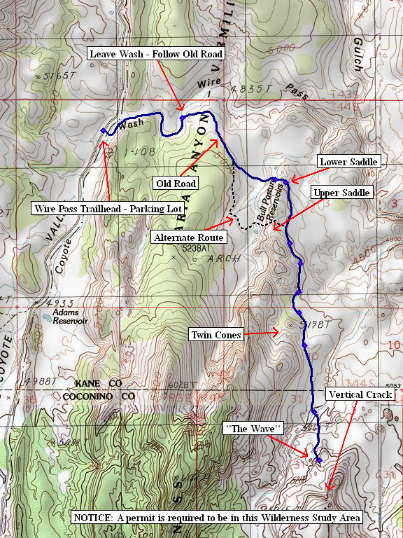 Map of 'The Wave' hike Map of 'The Wave' hike
road goes down Coyote Valley and Fivemile Valley WIRE PASS TRAILHEAD is 8.3 miles south of Highway 89 -- NO WATER - RESTROOMS! 5040 ft. elevation Follow the dirt road south-by-southwest along western side of The Cockscomb for about 8.3 miles BLM web site: https://www.az.blm.gov/paria/ Rules for Coyote Buttes: https://www.az.blm.gov/paria/coyotebuttes.html Frequently Asked Questions: https://www.az.blm.gov/paria/cbfaq2.html Obtain permits by phone/mail/contact info.: https://www.az.blm.gov/paria/contact2.html No dogs Max. of 10 persons per day in the Coyote Buttes South area (where "The Wave" is located Max group size is 6 persons Group leader MUSt display permit on OUTSIDE of backpack No campfires, no burning of trash, no toilet paper Pack out ALL garbage and waste Use existing routes, do not create new routes Commercial groups or guided trips require another special permit/fee $5.00 per person per day COYOTE BUTTES NORTH AREA!!!!!!!!! Follow the trail, follow the Coyote Wash through Wire Pass as it twists and bends. LEAVE WASH: North 37 deg. 01.198 min., West 112 deg. 01.081 min. (4815 ft.) Follow the dirt road/path up over the hill and down the gentle slope on the other side. Follow it almost all the way down to the bottom of the next wash. CLIMB HILL: North 37 deg. 00.941 min., West 112 deg. 00.595 min. (4879 ft.) Climb the hill to the east, up over the slick-rock ridge TURN SOUTH: North 37 Deg. 00.928 min., West 112 deg. 00.538 min. (4941 ft.) Turn and head south for "The Wave" - Stay high (to the right, to the west) on the slick-rock as much as possible, staying as level as possible. Do not be tempted to follow any trails leading down to the left (east) even if they seem well traveled. Some waypoints to help you keep on track: TURN SOUTH: North 37 Deg. 00.675 min., West 112 deg. 00.517 min. (5059 ft.) TURN SOUTH: North 37 Deg. 00.590 min., West 112 deg. 00.462 min. (5049 ft.) TURN SOUTH: North 37 Deg. 00.470 min., West 112 deg. 00.474 min. (5041 ft.) TURN SOUTH: North 37 Deg. 00.384 min., West 112 deg. 00.469 min. (5061 ft.) TURN SOUTH: North 37 Deg. 00.246 min., West 112 deg. 00.440 min. (5101 ft.) TURN SOUTH: North 36 Deg. 59.966 min., West 112 deg. 00.388 min. (5030 ft.) Climb about two hundred feet up to "The Wave" at 36 deg. 59.764 min. 112 deg. 00.365 min. A half-mile around or so is the confluence of 37 degrees and 112 degrees. I didn't visit it (I didn't realize I was so close) so I don't know how rough the half-mile or so of terrain is to reach it. | |